Resumen
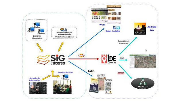
La evolución natural del SIG municipal conduce a la IDE de Cáceres, desde la que se pone a disposición de los usuarios toda la información recopilada en el sistema en los más de 20 años de experiencia.
En la IDE se han implementado distintos visualizadores. Pero para poder llegar a más, se propone una APP especialmente pensada para dispositivos móviles.
El objetivo de esta APP es publicar la información que se sirve desde la IDE local y desde otras fuentes externas. Se ha desarrollado de tal manera que se puedan actualizar los contenidos sin que sea necesario actualizar la aplicación.
Por este motivo, se divide en dos partes. Por un lado el denominado Generador de escenarios, que permite configurar diferentes entornos, cada uno con sus capas de información, y por otro la APP propiamente dicha (IOS y Android), que permite visualizar y consultar los datos incluidos en los escenarios definidos en el generador. Actualmente cuenta con 9 escenarios.
Desde el menú de la aplicación se pueden activar y desactivar las capas de información y capas base. También permite realizar búsquedas por calle, número y topónimo. Igualmente dispone de geolocalización.
Con casi 5000 descargas, esta aplicación acerca la IDE al usuario, reutilizando los propios servicios ofrecidos por el ayuntamiento. Este modelo es extrapolable a cualquier otro territorio que disponga de una IDE.
Palabras clave: INSPIRE, IDE, SIG, opendata, APP, IOS, ANDROID, WMS, TMS, GEOJSON.
Abstract
The natural evolution of the municipal GIS leads to the SDI of Cáceres, from which it is made available to users all the information collected in the system in more than 20 years of experience.
In this SDI, different viewerss have been implemented. But to be able to reach more functionality, an APP specially designed for mobile devices is proposed.
The objective of this APP is to publish the information that is served from the local SDI and from other external sources. It has been developed in such a way that the contents can be updated without it being necessary to update the application.
For this reason, it is divided into two parts. On the one hand, the so-called Scenario Generator, which allows the configuration of different environments, each one with its information layers, and on the other hand the APP itself (iOS and Android), which allows viewing and consulting the data included in the scenarios defined in the generator. Currently, it has 9 scenarios.
From the menu of the application you can activate and deactivate the information layers and basic layers. It also allows searching by street, number and place name, and it also has geolocation.
With almost 5000 downloads, this application brings the SDI to the users, reusing the web services offered by the city council. This model can be extrapolated to any other territory having a SDI.
Keywords: INSPIRE, IDE, SIG, opendata, APP, IOS, ANDROID, WMS, TMS, GEOJSON.
Autores
Faustino Cordero(1), Luis Antonio Álvarez (2)
Sección del SIG (Servicio de Urbanismo), Ayuntamiento de Cáceres
faustino.cordero@ayto-caceres.es (1)
luisantonio.alvarez@ayto-caceres.es (2)

Be the first to comment