Resumen
Los conjuntos de datos espaciales de imágenes, o ráster, ofrecen una visión intuitiva y amplia de la realidad, sin embargo, su análisis mediante técnicas de procesamiento espacial o geoprocesamiento resulta más difícil que usando datos vectoriales. En una ortofoto aérea –quizás el exponente más representativo de este tipo de de datos espaciales- es relativamente sencillo, si se cuenta con la resolución adecuada, apreciar la presencia o ausencia de un determinado fenómeno mediante inspección visual. Ahora bien, tareas como identificar automáticamente todos los emplazamientos que registran ocurrencias de un mismo fenómeno (por ejemplo, una construcción), generar representaciones geométricas de dichas ocurrencias o identificar en una secuencia temporal de imágenes cuando aparece por primera vez han sido difícilmente automatizables hasta la fecha y relegadas a trabajos de operador.
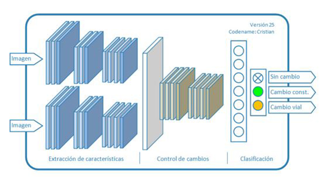
En el pasado, los intentos de automatizar el análisis y extracción de información en imágenes aéreas mediante técnicas de visión por computador han obtenido resultados de escasa aplicación práctica. En este artículo se presenta la utilización de técnicas de Machine Learning (Aprendizaje Automático) aplicadas a la detección automática de cambios utilizando ortofotos suministradas por servicios estándar de Infraestructuras de Datos Espaciales.
Palabras clave: inteligencia artificial, deep learning, machine learning, redes neuronales, control de cambios.
Abstract
Spatial image or raster data sets offer an intuitive and comprehensive view of reality. However, its analysis by spatial processing or geoprocessing techniques is more difficult than using vector data. In an aerial orthophoto – perhaps the most representative example of this type of spatial data – it is relatively simple, if it has the appropriate resolution, to appreciate the presence or absence of a certain phenomenon through visual inspection. However, tasks such as automatically identifying all the sites that record occurrences of the same phenomenon (for example, a construction), generating geometric representations of the mentioned occurrences or identifying in a temporal sequence of images when they appear for the first time have been difficult to automate until now and they have been relegated to operator jobs.
In the past, attempts to automate the analysis and extraction of information in aerial images by computer vision techniques have obtained results of little practical application. This article presents the use of Machine Learning techniques applied to the automatic detection of changes using orthophotos provided by the standard Spatial Data Infrastructure services.
Keywords: artificial intelligence, deep learning, machine learning, neural networks, change control.
Autores
Jose Julio Rodrigo, Juan Jorge Rosales
Departamento de Ingeniería, GRAFCAN
jrodrigo@grafcan.com
Director Técnico, GRAFCAN
jrosales@grafcan.com

Be the first to comment